


|
|
|
|
|
|
| |
| 23-OCT-2006 | Dave Beedon |
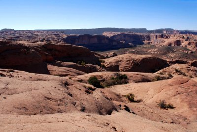
This view is to the northwest, looking at a bend in the Colorado River. Highway 128 is visible
inside the bend. About two miles downstream (to the left), the river meets Moab. The terrain to the
right of the river's bend forms the southern edge of Arches National Park. The ripply plateau at
upper left is the location of the Slickrock Trail, a world-famous mountain-biking route. Here I
am half a mile northeast of the Negro Bill Canyon trailhead, which is off to the left.
.
All images are copyright 1966 - 2023 by Dave Beedon (davebeedon AT comcast DOT net).