PX3 Prix De La Photographie Paris 2012
Honorable Mention for a series of 5 images "Death Valley"
International Photography Awards - IPA 2012
Honorable Mention in Fine Art - Landscape
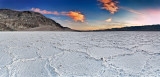
Badwater Basin is an endorheic basin in Death Valley National Park, Death Valley, Inyo County, California, noted as the lowest point in North America, with an elevation of 282 ft (86 m) below sea level. Mount Whitney, the highest point in the contiguous 48 states, is only 84.6 miles (136 km) to the WNW.
At Badwater, significant rainstorms flood the valley bottom periodically, covering the salt pan with a thin sheet of standing water. Each newly-formed lake does not last long though, because the 1.9 in (48 mm) of average rainfall is overwhelmed by a 150 in (3,800 mm) annual evaporation rate. This, the United States' greatest evaporation potential, means that even a 12-foot-deep, 30-mile-long lake would dry up in a single year. While the basin is flooded, some of the salt is dissolved; it is redeposited as clean crystals when the water evaporates
The site itself consists of a small spring-fed pool of "bad water" next to the road in a sink; the accumulated salts of the surrounding basin make it undrinkable, thus giving it the name. The pool does have animal and plant life, including pickleweed, aquatic insects, and the Badwater snail. Adjacent to the pool, where water is not always present at the surface, repeated freeze�thaw and evaporation cycles gradually push the thin salt crust into hexagonal honeycomb shapes. The lowest point (which is only slightly lower) is several miles to the west and varies in position. However, the salt flats are hazardous to traverse (in many cases being only a thin white crust over mud), and so the sign is at the pool.